
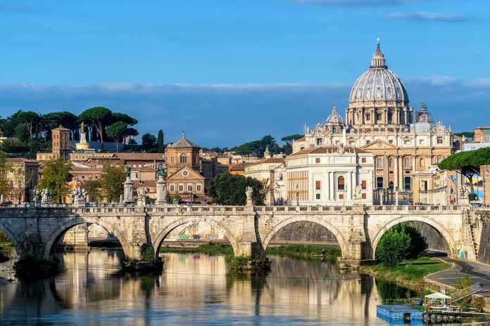
When the Tiber runs low, Rome’s past quite literally rises to the surface: the piers of the so‑called Bridge of Nero reappear, reminding us that climate stress doesn’t just threaten heritage — it makes it visible, again and again, in cycles as old as the river’s hydraulics and as current as a summer without rain.
At a Glance
- Exceptionally low water on the Tiber has repeatedly exposed the masonry piers of the ancient Pons Neronianus near today’s Ponte Vittorio Emanuele II.
- The structure is traditionally linked to Emperor Nero, but many scholars hold it may have first taken shape under Caligula; attribution is debated, not the bridge’s existence.
- This is a recurring drought-and-visibility pattern, not a one-off discovery; media interest surges when more of the piers break the surface.
- The bridge once connected the Campus Martius to the Vatican plain — a corridor to imperial properties and spectacles that shaped the city’s west bank.
What resurface events actually show: a known bridge, exposed by low flow
During summers of acute heat and scant rainfall, the Tiber’s discharge drops and its surface falls; when it does, the river yields stone. Locals and visitors have seen the same squat, time-worn piers thrust from the current near Castel Sant’Angelo and the Vittorio Emanuele II bridge — the remains of the Pons Neronianus, better known as “Nero’s Bridge.” In 2022, Italy’s worst drought in decades dropped levels enough that multiple piers stood clearly above water for weeks, a sight widely photographed and reported. The same pattern has recurred since: a dry, hot season, a lowered river, the bridge re-emerges; a normal winter and spring, and it slips back beneath the chop.
The mechanics are prosaic and powerful. The Tiber is a rain- and spring-fed system with seasonal variability baked into its regime. In prolonged drought, less inflow from the Apennine tributaries means the river rides lower against its embankments. The Pons Neronianus sat just downstream of where the Tiber’s flow narrows; when the water column thins, the top courses of ancient ashlar pierwork breach the surface, a textbook case of hydraulic exposure rather than archaeological “discovery”.
What the bridge was, where it sat, and why it mattered to imperial Rome
Topography is the key to understanding both the bridge’s purpose and its persistent mystique. The structure spanned the Tiber just below today’s Ponte Vittorio Emanuele II, linking the western edge of the Campus Martius — Rome’s populous, civic plain north of the traditional Forum core — to the Ager Vaticanus, the Vatican fields on the right bank. In the Julio-Claudian period, the imperial household held extensive properties there along the Via Cornelia, and the district hosted the Circus of Gaius and Nero, a venue with both political and ceremonial significance. A bridge at this point created a direct artery from city to spectacle and to palace land, an infrastructure decision as much about power and procession as about convenience.
Contemporary accounts and later catalogues name the crossing Pons Neronianus and, by the late Empire, treat it as the most straightforward route to the Vatican side from the city center. Its piers were still noted in early modern descriptions, long after the superstructure had vanished into reuse or collapse. By the third century, written and material signals suggest it had fallen into disrepair; Rome’s river crossings shifted slightly upstream and downstream as later emperors and modernizers selected new alignments that better matched changing urban traffic and the engineered embankments of the nineteenth century.
Nero, Caligula, or both? What attribution really means in this case
The name “Nero’s Bridge” is durable branding; the chronology is less tidy. Several lines of scholarship propose that the crossing began as a Julio-Claudian project tied to Caligula’s development of the circus complex — with a later rebuild or embellishment under Nero giving it the name that stuck. Others assign primary authorship to Nero on the strength of later literary references and numismatic hints. Either way, the bridge is a mid-first-century intervention; the dispute is about which emperor initiated which phase, not whether the structure existed. Open-access syntheses and specialist notes alike capture this consensus, while acknowledging the compressed and fragmentary nature of the physical remains and documentary record.
For the non-specialist, the practical upshot is straightforward. When drought exposes the piers, we are looking at a Julio-Claudian river crossing that served imperial lands and entertainment architecture on the Vatican plain, and which Roman routes later eclipsed. The slabs you see are not a misattributed modern curiosity; they are the footprint of that artery.
Drought and visibility are cyclical; novelty is in the degree, not the fact
Coverage of resurface events tends to treat each summer’s exposure as a fresh revelation. The pattern is more routine. Low-water seasons have revealed the Pons Neronianus piers repeatedly across years; what changes is how much stone emerges and for how long. In exceptionally lean summers, observers can count more pier courses or even discern the planform of multiple supports; in milder lows, a single crown of masonry peeks through and disappears after a storm. That is why sober accounts from 2019 and 2022 read much like those from later dry spells: same location, same ruins, different hydrograph. The bridge’s visibility is a barometer of the river’s stress — and, by extension, of the region’s hydrological balance.
This cycle fits a broader European pattern: drought drops water bodies to thresholds that reveal drowned villages, sunken craft, and ancient foundations; then replenishment veils them again. The real story is not discovery but recurrence — and what repeated recurrence at greater severity says about the background climate pressures reshaping river regimes, urban water management, and, by implication, the stewardship demands on heritage that lies within active channels.
How archaeologists read what little is visible — and what we still cannot see
River sites are stingy archives. Scouring currents strip away mortar, tumbled courses lie jumbled in eddies, and modern embankment works constrain access. When the Pons Neronianus piers show themselves, archaeologists exploit the window: mapping joint lines and block dimensions, noting offsets that hint at the bridge’s alignment, and cross-referencing with early topographic plans. Because only the uppermost surviving courses break water, most of the interpretation hinges on proportional analysis and the known spacing of Roman bridge piers elsewhere on the Tiber. It is a conservative craft, grounded in comparison — a method that keeps the claims modest and the identifications stable despite the meager exposure.
That methodological caution also explains the persistence of dual attributions. Without cofferdam excavations or a serendipitous inscription, dating rests on context: the bridge’s relationship to the Circus of Gaius and Nero, the urban growth of the Vatican fields, and the infrastructural sequences attested in texts of the early Empire. Within those bounds, “built by Caligula, rebuilt or named under Nero” remains the most coherent synthesis; attributing every stone to a single imperial phase oversells what the river is willing to yield.
Why the bridge matters now: heritage, water management, and urban memory
The Pons Neronianus matters for three reasons. First, it anchors how the city first formalized movement into the Vatican plain — a precursor to later crossings and, centuries on, to the pilgrim routes that redefined the right bank under different patrons and priorities. Second, it is a tangible index of the Tiber’s health: when more of it shows for longer, the river is running unnaturally low. Third, it sharpens a policy tension that cities from Rome to Seville face: much of their archaeological endowment sits in floodplains or channels that modern life still uses. Safeguarding those remnants requires decisions about riprap, dredging, navigation, and embankment maintenance that have consequences for both heritage visibility and flood risk.
As a public conversation piece, the bridge is unusually effective. You can stand on the quay below Castel Sant’Angelo and see a first-century infrastructure problem being solved in stone — a ruler linking people, property, and spectacle across a capricious river. When drought lays it bare, it also thrusts a twenty-first-century infrastructure problem into view: how to share the Tiber’s flow across ecology, recreation, supply, and safety in summers that arrive hotter and drier, more often. The sightline from Nero to now is shorter than it looks.
How to read the next resurfacing intelligently
Expect the Pons Neronianus to return to the headlines whenever the Tiber’s gauge dips. To make sense of those moments: look for the degree of exposure (one pier crown or several courses), note the location (just downstream of Ponte Vittorio Emanuele II), and treat Nero’s name as a shorthand for a Julio-Claudian crossing that served imperial lands — not as a precise building credit. If a report frames the view as a discovery, mentally replace it with recurrence. And if the stones stay visible deep into the season, worry less about novelty and more about what the hydrograph is telling you about the river that made Rome possible.
Sources:
kvia.com, livescience.com, lefigaro.fr, geo.fr, wetheitalians.com, news4jax.com, 24.hu, es.wikipedia.org, x.com